

This map is offered as a courtesy of GreatLakesBass.com only and is not to be taken as a 100% accurate reflection of law/regulation. Use at your own risk. You should always know and understand all state and local regulations of any area you intend to fish by contacting the proper authorities and checking official written sources. Ottawa County Sheriff: 616-738-4000; MDNR Plainwell: 269-685-6851
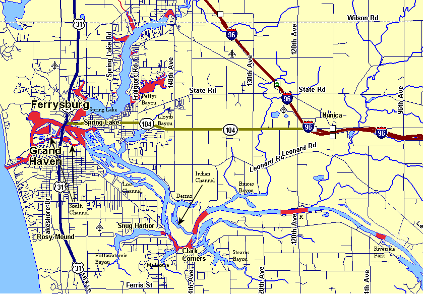
Areas in Red are enforced no wake zones for 2006 (printer-friendly version).
General State of Michigan No Wake Law/Regs – Maintain a distance of 100 feet from any dock, raft, buoyed or occupied bathing area, or vessel moored or at anchor, or shoreline where the water depth is less than 3 feet, as determined by vertical measurement, except in navigable channels not otherwise posted, except when the vessel is proceeding at a slow—no wake speed. “Slow—no wake speed” means a very slow speed whereby the wake or wash created by the vessel would be minimal. (Natural Resources and Environmental Protection Act, Act 451 of 1994 [Marine Safety Act]; Section 324.80149, Section 324.80146, Section 324.80104.amended Definitions)
Local Exception: All of Spring Lake not otherwise marked no wake has a 200 feet distance for all vessels under 26 feet in length. Vessels 26 feet and over, slow no wake all of Spring Lake.
Starting at Riverside Park, Grand River:
1) Marked by buoys in the river, slow no wake area of the entire river from just upstream of Riverside Park back downstream past the marina.
2) Slow no wake entire river from 120th Ave (near the MDNR ramp and previous site of Grand Valley Marina), marked by bouys in the river, upstream 1,500 feet (near powerlines) and downstream 2,500 feet (just past last cabin on south shore).
3) Slow no wake entire river, marked by buoys in the river, from the Grand River’s confluence with the Indian channel back upstream 3,500 feet (about half-way to Bruces bayou).
4) Slow no wake entire river, marked by buoys in the river, from 144th Ave (near Stearns Bayou) back downstream to a point almost to the mouth of Pottawatomie bayou that includes the main river channel waters of Grand Haven township; Includes the channel into Stearns bayou from the river to the boat ramp at the end of 144th Ave, and the channel into Millhouse bayou from the river to the Mercury Dr. bridge. Note: No wake signs on shore downstream from Pottawatomie bayou (towards the Lost channel confluence and Indian channel rejoin) on the main river are not approved by the MDNR and not being enforced per the Ottawa County Sheriff Marine division. 100 feet rules still apply. Many boats are going no wake from the channel markers at Lost channel back to Pottawatomie. Please take extra precautions.
5) Slow no wake, no buoys – sign only, Pottawatomie bayou from the mouth at the river for 500 feet westerly into the bayou.
6) Slow no wake, signs only, the entire length of the South channel.
7) Slow no wake, signs mostly, the entire Grand River from Lake Michigan back to a spot in the main navigation channel upstream several hundred feet from the Grand Haven sewage plant at the mouth of the Lost channel. Note: Main river no wake signs are usually on a large square wood pole on the northeast wild shore of the Grand River upstream from the Lost channel mouth – as of 7/26/06 the signs were missing from the pole – please take extra precautions. Side river channels in Spring Lake Village are no wake 4,000 feet easterly from the mouth of Spring Lake – channel edge signs exist in the affected channels.
8) Spring Lake is no wake, end of no wake in Spring marked by bouys, from the mouth at the Grand River out 1/4 mile into Spring Lake. All bayous (bays) in Spring Lake are no wake including Pettys, Smith, Stahl, Cornelius and Hammond, marked by signs, and buoys near the mouths of larger bayous. The north end of Spring Lake is no wake, marked by buoys, where less than 400 feet wide (Muskegon County).